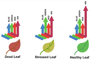
GeoSense ✅What is NDVI in Remote Sensing Analysis?“Normalized Difference Vegetation Index (NDVI) quantifies vegetation by measuring the difference between near-infrared (which vegetation…Apr 15, 20231Apr 15, 20231
GeoSense ✅Computing NDVI from Sentinel 2 ImageryNDVI is a vegetation index that utilizes the contrast between near-infrared light (which is highly reflected by vegetation) and red light…Apr 18, 2023Apr 18, 2023
GeoSense ✅Calculate the Normalised Burn Ratio (NBR) using Landsat 8 remote sensing data in PythonCalculate the Normalised Burn Ratio (NBR) using Landsat 8.May 10, 20231May 10, 20231
In𝐀𝐈 𝐦𝐨𝐧𝐤𝐬.𝐢𝐨byGeoSense ✅10 Common Vegetation Indices and Their Applications in Remote SensingVegetation indices are mathematical expressions that help to quantify the health, density, and vigor of vegetation from remote sensing…Mar 24, 20231Mar 24, 20231
InGeoinfomaticsbyGeoSense ✅Using Google Earth Engine (GEE), utilise the Sentinel-2 imagery to generate the Enhanced Vegetation…EVI from Sentinel-2 image on GEEJul 13, 20231Jul 13, 20231
InGeoinfomaticsbyGeoSense ✅Retrieving Leaf Area Index (LAI) Google Earth Engine (GEE)Retrieving Leaf Area Index (LAI)Jul 12, 2023Jul 12, 2023