InTDS ArchivebyNeel IyerSegment Satellite Imagery using NDVI and RasterioEasily Segment Canopy Cover and Soil using NDVI and RasterioJan 31, 2021Jan 31, 2021
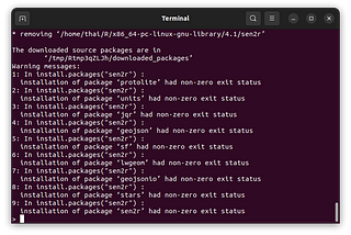
GeoSense ✅Installing Sen2r on Linux SystemsThis instruction shows how to install Sen2r which is an R library that helps to download and preprocess Sentinel-2 optical images.Jul 12, 2022Jul 12, 2022
GeoSense ✅Install libraries for geospatial applications in UbuntuThis instruction shows how to set up a Python (conda) environment on Ubuntu with gdal, rasterio, geopandas and other essential geospatial…Jul 11, 2022Jul 11, 2022
GeoSense ✅Install Python + GISHow to start doing GIS with Python on your own computer?Jul 14, 2022Jul 14, 2022